


The By Ways
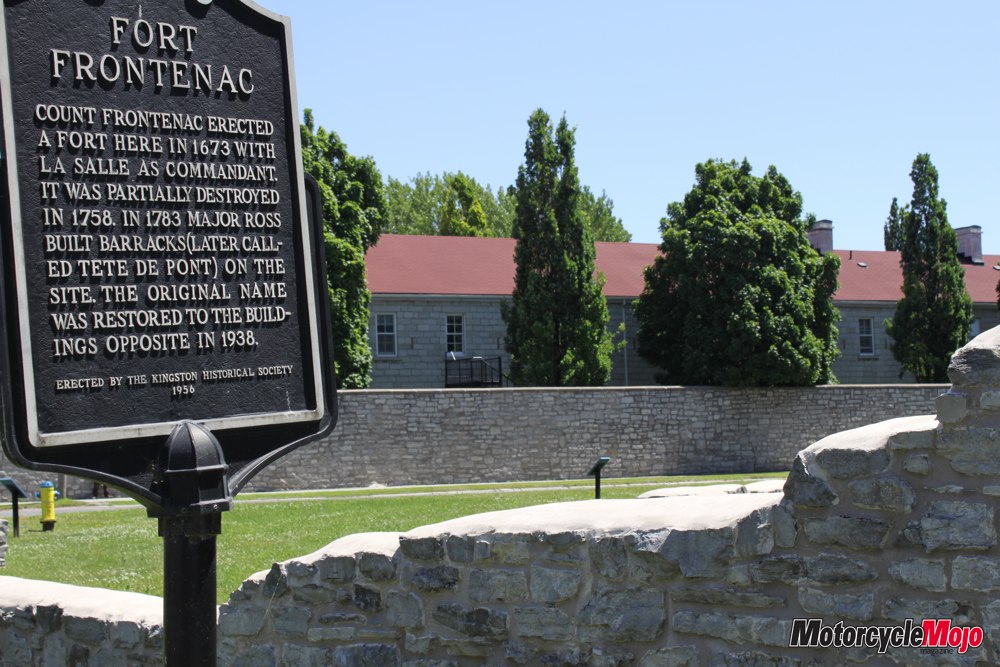
Sitting astride my motorcycle, I survey the ruins of old Fort Cataraqui and imagine myself here in the year 1673. Natives wander to and fro with stacks of beautiful animal furs. I hear the chatter of bartering French trappers. This is Upper Canada, known at the time as New France. The foundation remnant before me is all that remains of what was later called Fort Frontenac, built to control the lucrative fur trade in the Great Lakes Basin and later destroyed by the British conquest. In 1824, the new Fort Frontenac was completed across the street. Built of local limestone, it housed military troops during the War of 1812, and it is still in use today as a training facility for our military.
In 1826, Colonel John By of the Royal Engineers was assigned by the British government to supervise the construction of a navigable waterway between Ottawa and Kingston to afford protection from the Americans. Through wilderness, swamp, bush and solid rock, the canal was finished in six years and opened in 1832, a watery monument for over 1000 workers who died from malaria or accident during its construction. With 47 locks and 52 dams, today the 202-kilometre waterway is known as the Rideau Canal – one of the greatest engineering feats of the nineteenth century. In 2007, the Rideau Canal, the oldest continuously operated canal system in North America, became a UNESCO World Heritage Site. About to begin our tour along the Rideau, we first visit the Celtic cross overlooking the Cataraqui River, commemorating the workers who forfeited their lives building this edifice.
And thus begins our trip, as the bike wiggles this way and that on the open grating of the Lasalle Bridge. On my right is the Royal Military College, founded in 1874, in the shadow of Fort Henry, the last fort built in Canada. I turn left onto Highway 15 and catch glimpses of the Cataraqui River as I leave the amenities of Kingston for the backwater areas awaiting me.
At Codes Corners we follow Kingston Mills Road, and as we come out of a hollow and over a bridge, the blockhouse on our left and the locks beneath tell us we have arrived at Kingston Mills, the last of the Canal’s locks before Lake Ontario. With a lot of ground to cover today we are soon off again, running north on County Road 15, hunting for Washburn Road. A left turn up and over a small knoll brings us to locks 43 and 44 at Brewers Mills. Luckily, we are just in time to watch as the lockmaster manually opens the single-lane swinging bridge to allow a boat to pass through. The park-like setting at each lock allows overnight tenting for boaters passing through Brewers Mills.
Northbound again, we take a side trip northeast along CR33. It’s a perfect day for riding with excellent pavement, beautiful weather and wild flowers of every description in bloom along the roadside.
We approach the village of Lyndhurst and ride slowly across Ontario’s oldest bridge, spanning Lyndhurst Creek. Designed in 1856 by a local miller’s helper, it’s a triple-arched, single-lane stone bridge with flared entrances at either end, and it is still the main entrance and exit to the village. With children frolicking in the river below and folks lounging in the park, this is a scene of summer tranquillity.
We wind along CR33 and merge left onto CR42 to arrive in Delta. The Delta Mill on Beverley Lake is without a doubt the finest example of an early Ontario mill in pristine operating condition. Every Saturday, the miller sets the water wheel in gear and mills flour from which local ladies make hot bread for the tourists. Hot bread, slathered with butter – Oh how I wish it was Saturday.
With one more stop on today’s agenda, we ride through Philipsville and then left onto CR8 to Elgin. We eventually wind our way to Jones Falls. Here the Kenny Hotel, a stately old inn, overlooks the river and the lower locks. A long boardwalk takes us across the water to the first of four 15-foot locks that accommodate a 60-foot drop in water elevation. To our right, I can see the powerhouse at the bottom of the hand-built stone dam, 62 feet high. And we think that we have it tough today.
From here, I let my GPS lead me along CR11 to Sand Lake Road, Bush Road and Davis Lock Road, until we arrive again at Elgin. We ride north to Crosby to CR42 through Newboro and over to Westport, a pretty town on the shores of the Upper Rideau. Our destination for the night is the Cove Country Inn – we have made a good choice of this century home with a balcony overlooking the lake. The Jacuzzi tub is a welcome sight after a long day’s ride. We sit on the restaurant patio, overlooking the manicured lawn that slopes down to Westport Lake; the breeze is blowing, dinner is cooking and the ambience is perfect.
The next morning finds us backtracking to the Old Presbyterian Cemetery in Newboro. Here we find chunks of fieldstone used as markers for the sappers and miners who forced a channel through some of the hardest rock in Canada to join the Upper Rideau with Newboro Lake. They succeeded where two companies had failed, but many died. It seems that lives were an expendable commodity in times past. Another blockhouse is located at the Newboro locks, and along the roadways one can still see traces of the railroad that used to be the lifeline for industries in these communities.
We head south on CR15 to Chaffey’s Lock Road. As with many other roads in this area, it follows the contours of mother earth, and we lean left, right, up and down, enjoying every moment. The roadsides are covered with wild flowers as we roll by small farms eking out an existence with odd-shaped fields carved between rocky outcrops and woods. A chrome tanker blasts by us to pick up fresh milk at each little farm along the way.
Chaffey’s Locks is a gorgeous little hamlet, and The Opinicon is one of those old wooden clapboard resorts that date back to the early 19th century. At Brown’s Marina, we take a little pathway into the woods to find the cemetery, where again, fieldstone markers show where unfortunate canal workers were buried, mostly victims of malaria carried by a mosquito that we no longer have in Ontario.
We backtrack again at Crosby and take CR14 north to The Narrows. The excellent road surface and numerous sweeping bends make this another pleasurable ride. The Narrows has a single lock, one metre high, which separates the Big Rideau from the Upper Rideau. This lock represents the midway point of the canal – one side of the lock flows to Ottawa and the other to Kingston. I chat with the lockmaster, who is also a biker with his pride and joy parked in the shade of the blockhouse – another friendly lockmaster sharing a wealth of information, as has every other lockmaster during our travels.
The road is challenging from here to CR10. It seems the road-building rule here was no rock cuts and no filling in of low spots. The road follows the terrain and is great fun to ride at any speed. We choose a moderate pace in order to see everything we can: a doe and her fawn, a swamp full of lily pads, cattle huddled under a single tree to escape the hot sun, a heron flying off to its next swamp of choice, a turkey buzzard as it flies away from its roadkill lunch. Summer should last forever.
We turn right onto Perth Road, and then left to Glenn Tay, where the gentle Tay River gurgles along through this quaint little village. A right turn takes us into what’s been called the prettiest town in Ontario, Perth on Tay. After a brief stop at Codes Mill, we are off to Smiths Falls and the lock with the highest lift on the Rideau. At 26 feet, this new lock, built in 1974, takes the place of three previous locks and is operated by hydraulics rather than muscle power. Canada Day celebrations are underway in the park, and we take a leisurely stroll along the waterside as I show my wife where I first learned how to swim as a little boy of twelve. I am in my familial homeland now. Here, just beside the actual Smith Falls, is the Rideau Canal Museum, telling the story of the canal, complete with exhibits.
County Road 42 takes us along the shore of the Rideau River all the way to Merrickville, where the town is full of Canada Day partiers. We slowly make our way to the edge of town to the Ainsley B&B. Later, we dine at the Gads Hill Restaurant, named after Charles Dickens’ home in England. Evidently the owner is a big Dickens fan, as menus are tucked inside Dickens novels and the stone building is decorated with Dickens memorabilia.
The Merrickville Dam holds back water that is three feet above the road level. Across the street is the Alloy Foundry, built in 1846; it is the oldest foundry in Ontario and mainly made munitions until the end of World War II. Recently they completed a coat of arms for Prince William and Kate, which hangs in the Foreign Affairs office in Ottawa. The huge blockhouse, built to protect the locks, has a moat surrounding it and gun slots to shoot downward at would-be intruders and a tin-clad upper story, so torching the building would be difficult.
We take the River Road northward, and just before Lower Nicholsons lock, we stop at the entrance to a laneway. The sign on the gate says McGuigan Cemetery. Walking slowly up the laneway, we swat at the persistent deer flies until we come to a small rustic chapel clad with unpainted, weather-beaten boards. Resting here are even more canal victims, as witnessed by the fieldstone grave markers.
After a brief stop at Nicholsons Locks, we find the village of Burritts Rapids, named after Colonel Stephen Burritt, a United Empire Loyalist who fled to Canada from the United States. He was attracted to the area because of the potential for a water-powered mill. The steel swing bridge over the canal is dated 1897 and is still manually operated. We ride on through the Ottawa Valley farm country with its Victorian-style limestone homes, built by the canal workers after their jobs were finished. Fields filled with hay bales or newly planted corn spread across the landscape, and the fresh smell of country is in the air. I take in a deep breath as I roll into another lovely left-hander, and I’m thankful that my lot in life has not been to dig a canal in 1826. I cannot imagine working 14 to 16 hours a day with a shovel and a pick and nothing to look forward to other than doing the same thing again tomorrow, six days a week for several years. If we ever are tempted to complain, then I think we ought to ponder this.
At Lock 17 Restaurant we stop for a snack before heading on to Kemptville, Kars, Manotick and finally Hogs Back Dam in Ottawa. Three times a dam was built here, and each time it burst, the last time almost taking Colonel By with it. Other means were employed, and finally the dam held. Today the water level is controlled by modern methods. Upstream a heron gulps down his squirming uncooperative lunch while young people testing their skills walking on the slippery rocks, giving my wife some concern. A large outcrop in the middle of the rapids that would have looked like a hogs back before there was a dam here rightly gives this place its name.
From here we ride on the Colonel By Parkway, one of the most stress-relieving commutes in the world along the Rideau Canal. In winter, this stretch of the canal becomes the world’s longest skating rink at almost 8 km long. Ottawa, one of the most beautiful cities in North America, unfolds before us. The stately Parliament Buildings rise up on our left, as we roll past the Prime Minister’s residence on Sussex Drive. A left turn at the French embassy and we are at the end of our ride, Rideau Falls. It is said that when Champlain first sailed up the Ottawa River and set his eyes upon these falls, he exclaimed, “C’est un rideau!” or in English, “It’s a curtain!” It is indeed a spectacular site, and as we watch, the Empress of Ottawa, laden with tourists, sidles up to the falls; a moment its passengers will never forget, nor will I.
