


How many times have you been on a long ride, racking up tons of kilometres, but after the ride you feel like you haven’t seen a thing, and maybe you even feel a little disappointed. One of the reasons for this, at least in my case, is lack of proper planning.
Research can be a daunting, time-consuming task. You find places that are worthy of a visit and scratch the ones that sound kind of lame, only to find out later that a discarded location could have been a highlight of your trip. You really don’t know the best places unless you’ve been there, or if you are with a knowledgeable guide.
Earlier this year, I participated in an organized tour hosted by Vancouver-based Mid-life Crisis Tours. The “Canyonlands” tour began and ended in Las Vegas and looped around to various sights including state and national parks in Nevada, Utah and Arizona. All I had to do was show up and ride. No messy research necessary, since the tour company had already done the legwork to show the very best that a location had to offer. As an added bonus, I met some fantastic people on the tour with common interests in riding and taking in some amazing scenery.
Day 1: Las Vegas to Zion National Park
Jody Evans and Dave Blane, owners of Mid-life Crisis Tours, met us in the lobby of the Orleans Hotel and Casino on the morning of departure day and gave us a quick and professional briefing on riding protocol, safety and what we could expect during the next nine days. Both guys were easygoing and made us feel welcome from our very first meeting.
We mounted our bikes and rode out of Vegas on schedule to our first stop. I’ve been to Vegas before, and while many people love the hustle and bustle of the city of perpetual lights, it isn’t for me. I was, therefore, pleasantly surprised that a short ride of just over an hour put us well outside the city and in the Valley of Fire State Park. Colin Tremblay, driver of the support vehicle and all-around great guy, had planned ahead and prepared a picnic lunch for us, saving valuable riding time. He was diligent in arriving at a designated picnic location ahead of the riders and would have lunch ready when we arrived. Every day our lunch choices varied, and we never tired of the variety we were offered.
Geckos ran across our path during a walk in the desert sand between red sandstone formations where 3,000-year-old native petroglyphs are still visible. The stark beauty of the Mojave Desert is astounding, but I was told this was just the beginning and that there would be more magnificent vistas yet to come.
The 2012 Gold Wing I was riding is an awesome mount for lengthy highway travel, but the temperature was hovering in the 37°C (99°F) range and without a cloud in the sky, there was no reprieve from the blazing sun behind the big windshield. It was hot, but I knew there would be much cooler days ahead once we reached higher altitudes.
Our first day of riding ended at around 5 p.m. at the edge of Zion National Park at Zion Park Inn. With time to lounge around the pool, I took advantage of the downtime and got to know the other members of the tour.
There were Terry and Lori travelling on their Kawasaki Voyager; Scott and Pat aboard their Harley bagger; Jean-Guy and Hildegard on another Harley FLH; Ross riding solo on his Heritage Softail; Susan riding with Dave on their Kawasaki Voyager; and Jody taking the lead aboard his Yamaha Stratoliner. Dave owns and operates a trucking company, so he transferred everyone’s bikes, allowing the riders to fly in at their leisure. That’s one of the advantages of shipping your bike – you can save a week’s worth of holidays and can use the extra time to explore new areas.
Day 2: Zion to Capitol Reef National Park
The next morning we entered Zion National Park, and soon we were zigzagging on switchbacks beside towering walls of red rock as we scaled Bridge Mountain, the road eventually leading us to a 1.7-kilometre tunnel. Blasted through the mountain in 1930, I find it amazing that with just dynamite, rudimentary machinery of the day and sheer manpower, a feat like this could be accomplished. Periodically, we would pass by large holes created to provide light in the tunnel.
After Zion, we were in Bryce Canyon National Park looking down on thousands of hoodoos, which are created when softer sandstone is washed away, leaving behind the harder rock that eventually forms vertical towers. The vast number of these sentinels keeping watch over the canyon far below is incredible.
The temperature was down to 12°C (54°F) with very high winds when we stopped at the Grand Staircase overlook at an elevation of 2255 metres (7400 ft.). The winds were so high, in fact, that two bikes were caught just in time before they blew over in the parking area. A far cry from the temperatures of two days prior in the Valley of Fire.
Our day ended at the Capitol Reef Best Western. That evening’s dinner was in the neighbouring town of Torrey at Café Diablo. The establishment sported hundreds of devil masks throughout, and the food, along with its presentation, was the culinary highlight of the whole ride. Our server handmade all of the desserts, including the ice cream. One of the crew, who asked to remain anonymous, said, “The only thing wrong with this place is that now I have to go home and eat my wife’s cooking.”
Day 3: Capitol Reef to Moab, Utah
Day three began with a short but chilly 5°C (41°F) ride to Goblin State Park. The park is small, just a little square on the state map, but what it lacks in size it makes up in content. As in much of the Southwest, softer sandstone is washed away, in this case from an ancient sea, leaving the harder Entrada sandstone boulders balanced precariously high atop fragile sandstone spires. Many of the heavier, odd-shaped rocks, fallen off their perches over the millennia, look like scattered goblins.
The landscape was noticeably changing from red sandstone to sheer red cliffs, and to add some contrast, there were 10- to 30-metre, lunar-looking, rolling grey hills that looked like wrinkled elephant skin. Then in no time we passed through a massive desert. Windstorms had created sand drifts that blocked parts of the highway. There was a bulldozer, half covered in sand, waiting silently for an operator who would move the sand back to its rightful location.
Before reaching our day’s destination of the Red Cliffs Lodge just outside of Moab, Utah, we stopped at various look-offs created over millions of years of erosion by the rivers far below, and we played hopscotch with the Colorado River. On one stretch of Highway 191, we rode amongst 300-metre cliffs on both sides; it’s just the road and the river in the canyon, while off in the distance are the jagged, snow-capped mountains of the La Sal Range.
Red Cliffs Lodge, sandwiched between Scenic Byway 128 and the Colorado River, would be our home for the next two days. Before we called it quits for the day, Jody and I ventured out on our own and rode the 100 km La Sal Mountain loop. Starting in low lands, we quickly climbed to snow-covered peaks on blind, hairpin corners. Signs warn of free-range livestock, and on one particular blind corner, a herd of cows blocked the road; Jody almost bagged himself a freezer full of beef, and I almost cleaned out the back end of a Stratoliner”Once again on this trip, I was very grateful for the Gold Wing’s ABS.
DAY 4 NATIONAL PARK
We didn’t have to pack up this morning, so we were able to get an early start to Arches National Park. Over 2,000 documented arches exist in the park, but while new ones are being created (over millions of years), many ancient arches are also caving in. One of the most spectacular, and the longest arch in the park, is the Landscape Arch, measuring 90 metres wide at the base. An easy 1.3 km hike will offer an outstanding view, but won’t allow you to get too close. In 1991, a 20 × 3 × 1 metre, 180-ton piece of rock fell from one side, making that side of the arch dangerously thin.
Another highlight of the park is the Delicate Arch. This one is much more work to get to, even though the trail is only 2.4 km long, but the trail’s elevation change is 146 metres, all uphill. Perched on the edge of a cliff, this arch is accessible up close and personal, and from the main viewing point, the arch’s opening frames part of the snow-capped La Sal Mountains far off in the distance.
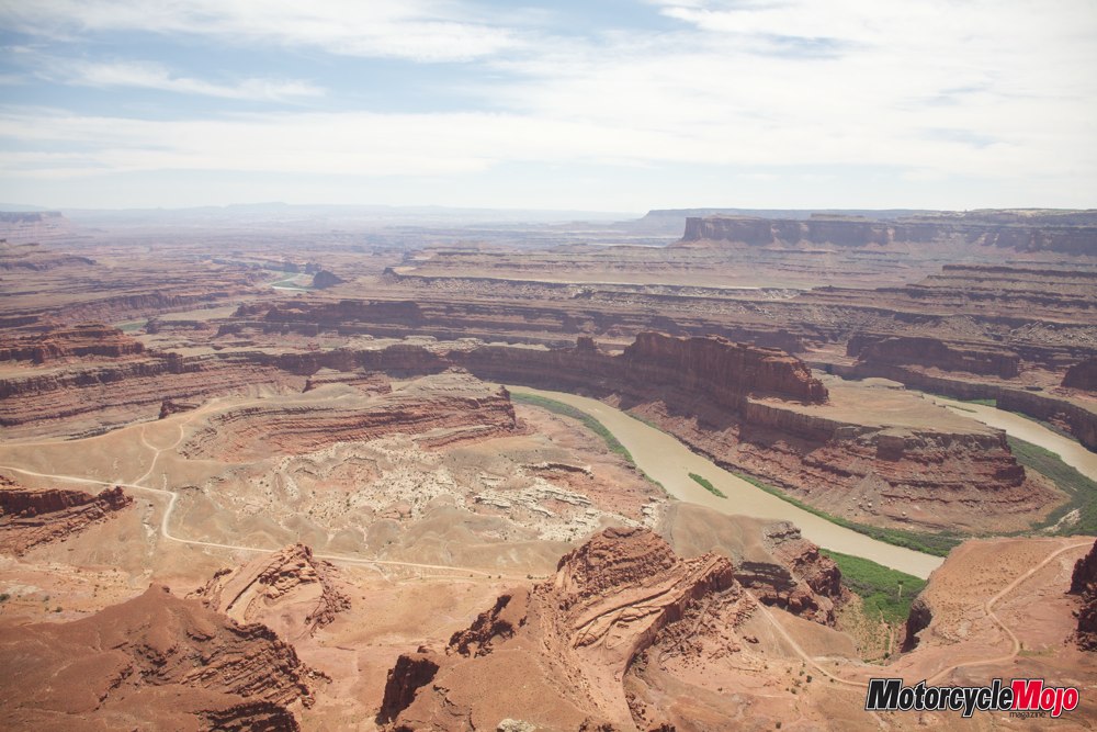
To top off a spectacular day of scenery, we finished up at Dead Horse Point State Park, with an amazing view of the Colorado River far below.
DAY 5 MEXICAN HAT
Leaving Red Cliffs Lodge on day five, we took Highway 191 through Moab, stopping at Hole N’ The Rock. This is a tourist attraction that I would never in a million years have imagined stopping at, but because the tour company did the legwork and deemed it worthy of a stop, I conceded. While it doesn’t offer spectacular scenery, it is amazing to see how a father with a penchant for dynamite first carved a bedroom for his sons out of solid rock. Over time, and after removing an estimated 70,000 cubic feet of rock, it became a 14-room, 5,000 sq. ft. home. It looks corny and tacky from the road, but it is worth the $5 admission fee.
We continued south on 191 to 163, then turned right onto Utah Route 261. This was a gravel road that led to the edge of the 340-metre-high Cedar Mesa, which overlooks the Valley of the Gods. I have never experienced such a vast view while standing on terra firma; the road far below, which we would soon be on, looked like a thin piece of ribbon. Ross, being afraid of heights, didn’t venture too close to the edge, but soon realized that he would have to face his fears and ride down the five-kilometre, steep gravel road called the Moki Dugway to get to the bottom. At least the hairpins were paved, sort of.
This day included many stops at scenic vantage points, including Goosenecks State Park. As we were riding up to the canyon, off in the distance, two fighter jets entertained us with a display of aerial acrobatics. Getting closer to the ground, one pulled up and the other disappeared into the horizon – I was half expecting an explosion – but we soon realized that the other jet had gone into the canyon. I only wished we had gotten to Goosenecks five minutes earlier to see the jet fly through the canyon. At the Goosenecks vantage point, far below is the vast winding result of 170 million years of erosion caused by the San Juan River.
We called it quits in Mexican Hat, a town named after a large hoodoo, the top of which looks like a Mexican hat. I wondered if they would change the name of the town when the hat falls, which it will in time. The night was topped off with the first Stanley Cup game between the Canucks and the Bruins. Seeing that everyone except yours truly was from the Vancouver area, there was no way we were going to miss it. The Canucks won that nailbiter 1–0 in the last 18 seconds of the game.
DAY 6 PAGE, ARIZONA
The next morning, we crossed into Arizona with Monument Valley in our sights. Impossible to miss, the road leading to this majestic landmark is arrow straight. Stopping at the Navajo Tribal Park visitor centre, we found out that one particular area of the wraparound deck afforded John Wayne’s favourite view; it’s obvious by the posters and placards that he made many movies in this area. On the lower level, there is a museum dedicated to the Navajo code talkers of the Second World War. Their native tongue enabled the Allies to communicate in a way that the enemy couldn’t understand, helping win the war in the Pacific.
After leaving Monument Valley on Highway 163 south, we turned west onto SR 98 toward Page and arrived at the much-anticipated Antelope Canyon, owned and operated by the Navajo Nation. This wonder of nature is not listed on my CAA map, but as a reference, the canyon is right beside the listed Navajo Power Plant, just east of Page.
Many areas in the desert are subject to flash floods from rains in the nearby mountains, and because these rains occur with such speed and ferocity, the water doesn’t have time to sink into the ground, so instead the water follows a dried riverbed called a “wash.” A flash flood can rush down a canyon in a wall of water twelve feet high or more.
Antelope Canyon is a result of these flash floods. Millions of years ago, the water found its way underground below this wash through a small crevice, and eventually, the high pressure of rushing water created this underground canyon of smooth, flowing, curved walls. It is quite possibly the most amazing place I have ever seen.
To enter, we had to turn sideways to squeeze our way through a small crevice, and then follow the canyon down through a series of ladders that eventually take you about 20 metres below ground level, all the while following the flowing curves that the rushing water has created. The canyon ends with one long staircase to the wash above.
A small monument above the crevice reminds visitors how dangerous the floods can be. A few years ago, many people lost their lives when a flash flood ripped through the underground canyon. Now sirens warn if rain is detected in the highlands.
Riding only 255 km today made for an early stop in Page, Arizona, allowing us to catch up on laundry or just to lounge around the pool.
DAY 7 SEDONA
We left Page on 89 South and then to SR 64, en route to the South Rim of the Grand Canyon. It’s obvious this place is big, but seeing it in person renders it unfathomable in size. I have never seen any one thing vast enough to compare it to. While we were taking in the view, Colin had set up lunch just a few metres from the edge of the Canyon, which allowed us to take in the enormous spectacle while once again enjoying a picnic lunch.
We continued south on SR 64 in the direction of Flagstaff and then onto Arizona’s high desert area on SR 89A to Sedona. The landscape was once again changing to green fields and trees and less sandstone, desert and sagebrush. Approach to Sedona was via Oak Creek Canyon. From the lookout high above the canyon to the entry into Sedona along Oak Creek has to be one of the most serene and prettiest roads I have ever ridden.
DAY 8 KINGMAN
A few in our group decided to shop in Sedona while Jody, Terry and I took SR 179 to Montezuma Castle, a twelfth-century, 20-room dwelling built 30 metres above the ground into a cliff by the Sinagua Indians.
A short stint on the Interstate, and then SR 260 led us into “America’s most vertical city.” Jerome was a mining town, turned ghost town, turned hippy hangout, turned artsy tourist attraction. Built on a mountainside, the road winds up Cleopatra Hill into the centre of town. The downtown hub is still much like it was 100 years ago, but age and gravity has taken its toll on a few of the town’s buildings, as they are now spread down the hillside in crumpled heaps.
After meeting up with the rest of the group that we left in Sedona, we continued on to Prescott Valley. This stretch of 89A is not to be missed. With 158 curves in 19.5 kilometres, the Mingus Mountain Drive is no Tail of the Dragon, but it is just as entertaining with much better scenery, provided you dare take your eyes from the road to enjoy the mountain panoramas.
We wound our way north onto Historic Route 66 through Seligman. I saw five cars on the four-lane main street while we took a two-hour break in Seligman. Towns that are on Route 66, once called the “Main Street of America” or the “Mother Road,” suffered a quick painful death in the desert sun when the I-40 was constructed. We continued on Route 66 to Kingman, where Jody had booked us into another Best Western.
DAY 9 LAS VEGAS
This was our last day of the Mid-life Crisis Tour, but before heading back toward Vegas, we continued on Route 66 to the ghost town of Oatman. There are stretches of Route 66 that are arrow straight, sometimes disappearing into the horizon, but as we climbed into the low-lying mountains leading to Oatman, the road became a twisty ribbon of rough tarmac with hairpin turns as we clung to the side of the mountains. Remnants of mines big and small dotted the landscape, as Oatman was once a thriving gold-mining town from 1904–1931 with an estimated area population of 10,000. When the prospectors left, they turned their burros loose, leaving them to fend for themselves. Thousands of wild burros still live in the surrounding Southwest deserts, but quite a few of them prefer the easy life and rely on being fed by the tourists who come to Oatman year-round to see them. In town, you ride at walking speed or less, as some of the burros may decide to take a nap in the middle of the road, or just walk out to inspect the new visitors. Today, the town only takes up about four blocks on Main Street, and the bars, restaurants and stores are still open for business, making the ride there and back an enjoyable way to spend a day.
Heading back the way we came, we picked up Highway 93 in Kingman and headed for the Hoover Dam before making our final ride as a group into Vegas and back to the Orleans Hotel and Casino, where it all began nine days prior.
The nine-day total was just over 3000 km; our shortest day was around 224 km and the longest day was just over 400 km. The general consensus amongst all of us on the tour was that we would happily go on one again; all the planning and research work is done for you, hotels are booked, gas stops planned, the best spots are already scoped out and there is time to stop to see the sights and smell the roses. That is something I don’t do when I’m riding on my own. We saw many more sights than mentioned here, and being off the road at a decent hour allowed us to enjoy some downtime before dinner.
Jody and Dave were exceptional hosts, very professional and accommodating, and it’s obvious they took the time to do it right. They had a really good thing going, so I am saddened to say that Mid-life Crisis Tours has suspended operations for the time being, citing unexpectedly high operating costs. I really hope that they will start up again in the near future, and I will be sure to let you know the company’s status as I hear any news.
I know many of you wouldn’t consider going on an organized tour, but I promise that once you try a reputable company, you will appreciate the effort that goes into making it an invaluable experience, if for nothing more than the level of planning and knowledge that they can bring to the table to make your riding holiday the most it can be.


